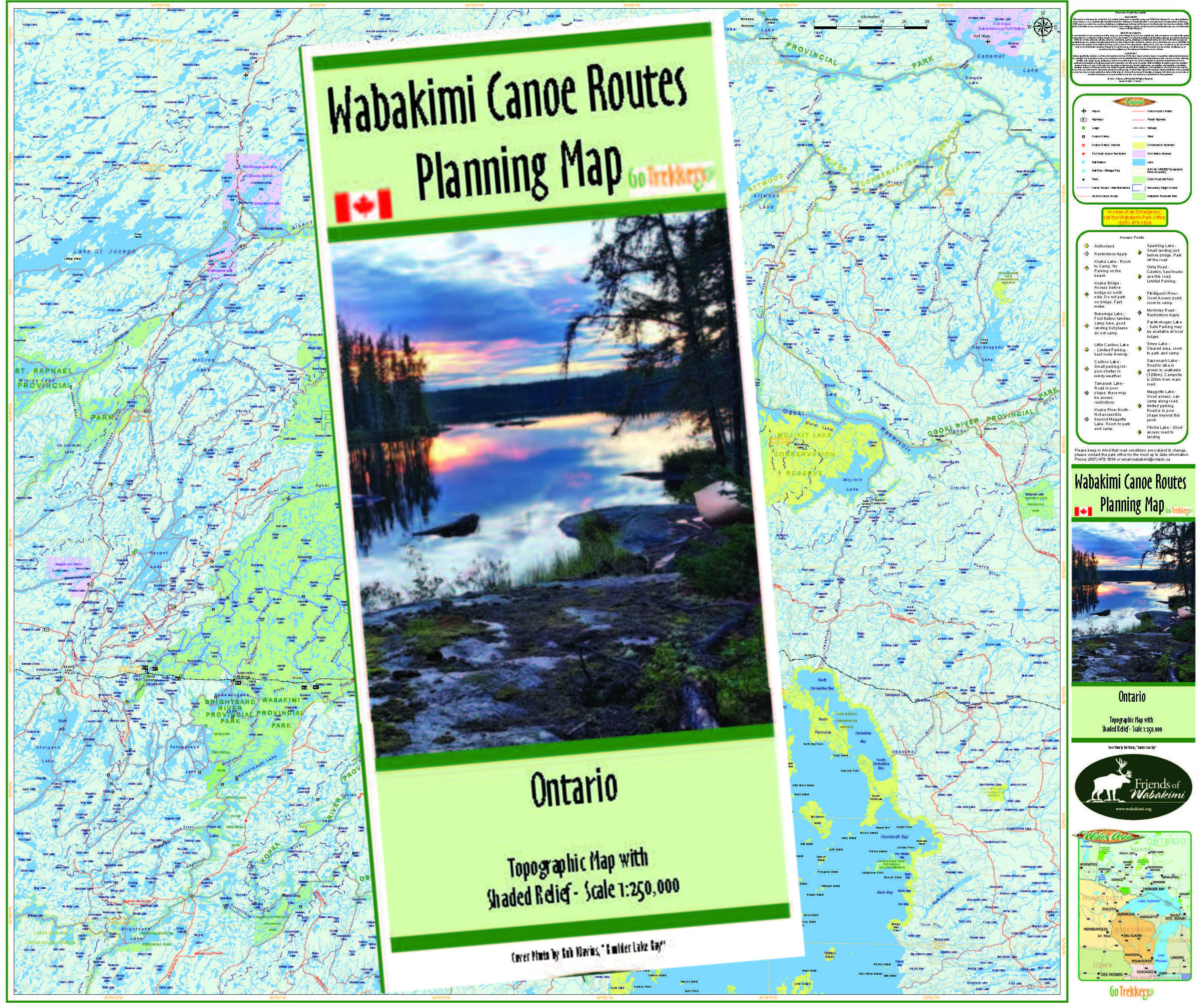
Wabakimi Canoe Routes PLANNING MAP - 35" by 41.5" (Price in CND)
Description
UPDATED PLANNING MAP IS HERE (Log in for our Members price!)
New features on the FOW Map include: train stops, entry points, lodges & outposts & direction of flow. Produced by GoTrekkers Maps. A synthetic version is availabe directly from GoTrekkers.
The new map is based on our first edition, produced by “Uncle” Phil Cotton working with professional cartographers and published by the Friends of the Wabakimi. In a readable scale of 1:210,000 this is the only map of its kind to depict all the known canoe routes in the Historic Wabakimi Area, which includes the Wabakimi Provincial Park and eight surrounding Provincial Parks. It also includes; the Mojikit Lake, Attwood River, Ottertooth and Lake Nipigon Conservation Reserves; and bordering Crown lands forests. Information also shows the access points from the paved highways, forest roads, and Canadian National Railway line that runs east--west through this vast wilderness area.
This attractive map shows the primary and secondary heights of land, lakes and rivers, the provincial parks and conservation reserve boundaries as drawn from the Ontario Ministry of Natural Resources (OMNR) data set. The backdrop of the map is a "3-D" geotiff image created from the OMNR 20m Digital Elevation Model.
Grid lines every 30 minutes of longitude and every 15 minutes of latitude define the coverage of the 1:50,000 Provincial Series of topographical maps with Topo map index numbers provided at the grid intersection points over the entire extent of the map.
Printed in full color this 36" x 35" map covers 43,000+ square kilometers (16,500 square miles) of pristine wilderness.
-
 101 Allanwater River to Wabakimi Lake , Lower Wabakimi, Caribou River, Little Caribou Lake take -out, with options & Allanwater-Flindt connection
$25.00$18.75 - Member price
101 Allanwater River to Wabakimi Lake , Lower Wabakimi, Caribou River, Little Caribou Lake take -out, with options & Allanwater-Flindt connection
$25.00$18.75 - Member price -
 102 Allanwater River via Whitewater to Little Caribou
$20.00$15.00 - Member price
102 Allanwater River via Whitewater to Little Caribou
$20.00$15.00 - Member price -
 103 Allanwater, Berg, Whitewater, Little Caribou
$20.00$15.00 - Member price
103 Allanwater, Berg, Whitewater, Little Caribou
$20.00$15.00 - Member price -
.jpg) 104 Allanwater, Whitewater, Boiling Sand to Bath Lake (or Tamarack Lake)
$20.00$15.00 - Member price
104 Allanwater, Whitewater, Boiling Sand to Bath Lake (or Tamarack Lake)
$20.00$15.00 - Member price -
 105 Boiling Sand and Berg Rivers,Whitewater to Little Caribou
$20.00$15.00 - Member price
105 Boiling Sand and Berg Rivers,Whitewater to Little Caribou
$20.00$15.00 - Member price -
 106 Flindt River via Kenoji and Whitewater Lakes, to Boiling Sand River (or shortcut to Smoothrock Lake)
$25.00$18.75 - Member price
106 Flindt River via Kenoji and Whitewater Lakes, to Boiling Sand River (or shortcut to Smoothrock Lake)
$25.00$18.75 - Member price -
 107 Flindt River via Kenoji and Whitewater Lakes (or Lower Wabakimi) to L. Caribou
$25.00$18.75 - Member price
107 Flindt River via Kenoji and Whitewater Lakes (or Lower Wabakimi) to L. Caribou
$25.00$18.75 - Member price -
 108 Kopka River - shorter trip from Aldridge Creek train stop
$20.00$15.00 - Member price
108 Kopka River - shorter trip from Aldridge Creek train stop
$20.00$15.00 - Member price -
 109 Kopka River Complete - Allanwater Bridge-Brightsand South-Kopka River to Bukemiga and more
$25.00$18.75 - Member price
109 Kopka River Complete - Allanwater Bridge-Brightsand South-Kopka River to Bukemiga and more
$25.00$18.75 - Member price -
 110 Lookout River, Smoothrock, Berg, Whitewater, Little Caribou Lake (with options)
$20.00$15.00 - Member price
110 Lookout River, Smoothrock, Berg, Whitewater, Little Caribou Lake (with options)
$20.00$15.00 - Member price -
 111 Magotte Lake or Shultz's Trail, Lookout River, Elf Lake, Allanwater, Caribou to Little Caribou Lake take-out
$20.00$15.00 - Member price
111 Magotte Lake or Shultz's Trail, Lookout River, Elf Lake, Allanwater, Caribou to Little Caribou Lake take-out
$20.00$15.00 - Member price -
 112 Nemo River to Little Caribou, with several route choices
$25.00$18.75 - Member price
112 Nemo River to Little Caribou, with several route choices
$25.00$18.75 - Member price -
 113 Allanwater,Brennan Lake, Nemo River loop
$18.00$15.00 - Member price
113 Allanwater,Brennan Lake, Nemo River loop
$18.00$15.00 - Member price -
 114 Lookout River -- Onamakawash Lake to Lookout River, Smoothrock Lake, Caribou River and the Little Caribou
$15.00$12.00 - Member price
114 Lookout River -- Onamakawash Lake to Lookout River, Smoothrock Lake, Caribou River and the Little Caribou
$15.00$12.00 - Member price -
 115 Lookout River to Smoothrock Lake, Whitewater Lake returning south to Boiling Sand River with options
$15.00$12.00 - Member price
115 Lookout River to Smoothrock Lake, Whitewater Lake returning south to Boiling Sand River with options
$15.00$12.00 - Member price -
 120 Big River Route. From Big Lake Road to Gort Lake and Pikitigushi Lake take-out
$15.00$12.00 - Member price
120 Big River Route. From Big Lake Road to Gort Lake and Pikitigushi Lake take-out
$15.00$12.00 - Member price -
 125 Bukemiga Lake loop via Collins River, Onamakawash Lake and Kopka River
$20.00$15.00 - Member price
125 Bukemiga Lake loop via Collins River, Onamakawash Lake and Kopka River
$20.00$15.00 - Member price -
 130 Chivelston and Harris and Neston Lakes to Heathcote, Smye and Wilkie Lake to Flindt River.
$10.00$7.50 - Member price
130 Chivelston and Harris and Neston Lakes to Heathcote, Smye and Wilkie Lake to Flindt River.
$10.00$7.50 - Member price -
 201 Pashkokogan Lake, Shoe Creek to Davies Lake, Palisade River, Redman Lake to Rockliff Lake, Greenbush to Pashkokogan.
$15.00$12.00 - Member price
201 Pashkokogan Lake, Shoe Creek to Davies Lake, Palisade River, Redman Lake to Rockliff Lake, Greenbush to Pashkokogan.
$15.00$12.00 - Member price -
 205 Fitchie to Pashkokogan Lake (Hwy 599) or Osnaburgh Lake (Hwy 599) six choices of route
$15.00$12.00 - Member price
205 Fitchie to Pashkokogan Lake (Hwy 599) or Osnaburgh Lake (Hwy 599) six choices of route
$15.00$12.00 - Member price -
 215 Pikitigushi River From Little Caribou via Smoothrock Lake, Berg and Ogoki Rivers to Whitewater Lake, Whiteclay Lake and south to the Pikitigushi River and the logging road take-out
$20.00$15.00 - Member price
215 Pikitigushi River From Little Caribou via Smoothrock Lake, Berg and Ogoki Rivers to Whitewater Lake, Whiteclay Lake and south to the Pikitigushi River and the logging road take-out
$20.00$15.00 - Member price -
 218 Linklater Lake, Linklater Creek, D’Alton Lake, Big River connections between Caribou Lake and Pikitigushi River
$15.00$12.00 - Member price
218 Linklater Lake, Linklater Creek, D’Alton Lake, Big River connections between Caribou Lake and Pikitigushi River
$15.00$12.00 - Member price -
 221 A loop trip from Little Caribou Lake via Caribou River, Smoothrock Lake, Berg and Ogoki Rivers to Whitewater Lake and return to the Little Caribou Lake take-out
$15.00$12.00 - Member price
221 A loop trip from Little Caribou Lake via Caribou River, Smoothrock Lake, Berg and Ogoki Rivers to Whitewater Lake and return to the Little Caribou Lake take-out
$15.00$12.00 - Member price -
 222 Little Caribou, Berg, Whitewater Lake to Boiling Sand River, Collins Lake, Shawanabis, Kopka to Bukemiga take-out
$20.00$15.00 - Member price
222 Little Caribou, Berg, Whitewater Lake to Boiling Sand River, Collins Lake, Shawanabis, Kopka to Bukemiga take-out
$20.00$15.00 - Member price -
_Page_01.jpg) 223 Little Caribou via McKinley and Whitewater Lakes to the Little Jackfish River
$20.00$15.00 - Member price
223 Little Caribou via McKinley and Whitewater Lakes to the Little Jackfish River
$20.00$15.00 - Member price -
 224 Little Caribou Loop via Linklater, Big River, Raymond River, Whiteclay, Whitewater
$20.00$15.00 - Member price
224 Little Caribou Loop via Linklater, Big River, Raymond River, Whiteclay, Whitewater
$20.00$15.00 - Member price -
 225 Collins River from Bukemiga Lake (Hwy527) to Rushbay and Tamarack Lake and on to Smoothrock Lake and Little Caribou exit
$15.00$12.00 - Member price
225 Collins River from Bukemiga Lake (Hwy527) to Rushbay and Tamarack Lake and on to Smoothrock Lake and Little Caribou exit
$15.00$12.00 - Member price -
 230 Wabinosh River and various routes from Tamarack Lake via Vale Lake or Rushbay to Waweig or Mattice Lake
$10.00$7.50 - Member price
230 Wabinosh River and various routes from Tamarack Lake via Vale Lake or Rushbay to Waweig or Mattice Lake
$10.00$7.50 - Member price -
 250 Nameiben, Tunnel, Boiling Sand, Elf, Little Caribou Lakes
$20.00$15.00 - Member price
250 Nameiben, Tunnel, Boiling Sand, Elf, Little Caribou Lakes
$20.00$15.00 - Member price -
 305 Ogoki River from Savant Lake to the Ogoki Reservoir with an exit South on the Little Jackfish River
$20.00$15.00 - Member price
305 Ogoki River from Savant Lake to the Ogoki Reservoir with an exit South on the Little Jackfish River
$20.00$15.00 - Member price -
 310 Burntrock Lake fly-in, to Whitewater Lake, Smoothrock Lake, Boiling Sand River or alternate finish via Caribou River and the Little Caribou Lake take-out
$20.00$15.00 - Member price
310 Burntrock Lake fly-in, to Whitewater Lake, Smoothrock Lake, Boiling Sand River or alternate finish via Caribou River and the Little Caribou Lake take-out
$20.00$15.00 - Member price -
 317 Dawn Lake loop, Kenoji Lake and Pallisade River
$15.00$12.00 - Member price
317 Dawn Lake loop, Kenoji Lake and Pallisade River
$15.00$12.00 - Member price -
 320 Palisade River loop, with links to Coles Lake and Albany and Webster to Slim River
$15.00$12.00 - Member price
320 Palisade River loop, with links to Coles Lake and Albany and Webster to Slim River
$15.00$12.00 - Member price -
 325 Albany River from Rockcliff Lake to Attwood, Witchwood and Pikitigushi River
$35.00$28.00 - Member price
325 Albany River from Rockcliff Lake to Attwood, Witchwood and Pikitigushi River
$35.00$28.00 - Member price -
 330 Albany River (from Hwy 599) to Attwood, Witchwood and Pikitigushi Rivers
$35.00$28.00 - Member price
330 Albany River (from Hwy 599) to Attwood, Witchwood and Pikitigushi Rivers
$35.00$28.00 - Member price -
 332 Shabuskwia River from Patte Lake (Albany River) via Attwood and Opichuan Rivers to Mahamo Lake - with two alternate routes south
$20.00$15.00 - Member price
332 Shabuskwia River from Patte Lake (Albany River) via Attwood and Opichuan Rivers to Mahamo Lake - with two alternate routes south
$20.00$15.00 - Member price -
 350 The Brightsand River Provincial Park plus the Brightsand Circle and Hilltop Lake loops
$20.00$15.00 - Member price
350 The Brightsand River Provincial Park plus the Brightsand Circle and Hilltop Lake loops
$20.00$15.00 - Member price -
 503 Flindt to Allanwater Connection via Gault and Stump Lakes SUPPLEMENTAL
$5.00$3.50 - Member price
503 Flindt to Allanwater Connection via Gault and Stump Lakes SUPPLEMENTAL
$5.00$3.50 - Member price -
 504 Linklater, Revillo, MacDonald, Linklater Creek, MacLaren Lake, Upper & Lower Pawshowconk Lakes, Big River, to Gort Lake to Pikitgushi river route
$15.00$12.00 - Member price
504 Linklater, Revillo, MacDonald, Linklater Creek, MacLaren Lake, Upper & Lower Pawshowconk Lakes, Big River, to Gort Lake to Pikitgushi river route
$15.00$12.00 - Member price -
 510 Raymond River Route: Little Caribou to Pikitigushi River plus an Alternate loop finish to Whiteclay, Whitewater and back to Little Caribou
$20.00$15.00 - Member price
510 Raymond River Route: Little Caribou to Pikitigushi River plus an Alternate loop finish to Whiteclay, Whitewater and back to Little Caribou
$20.00$15.00 - Member price -
 All Five FOW Map Volumes Combined (PDF DOWNLOAD)
$100.00$80.00 - Member price
All Five FOW Map Volumes Combined (PDF DOWNLOAD)
$100.00$80.00 - Member price -
 Large Canoe Sticker "Explore Wabakimi"
$8.00$5.00 - Member price
Large Canoe Sticker "Explore Wabakimi"
$8.00$5.00 - Member price -
 Large Canoe Sticker "Friends of Wabakimi"
$8.00$5.00 - Member price
Large Canoe Sticker "Friends of Wabakimi"
$8.00$5.00 - Member price -
 Smoothrock to Elf, McWade & Granites Lakes SUPPLEMENTAL
$5.00$2.50 - Member price
Smoothrock to Elf, McWade & Granites Lakes SUPPLEMENTAL
$5.00$2.50 - Member price -
.jpg) True & Deep, Songs for the Heart of the Paddler, JERRY VANDIVER, includes "Wabakimi" (Price is CAD)
$15.00
True & Deep, Songs for the Heart of the Paddler, JERRY VANDIVER, includes "Wabakimi" (Price is CAD)
$15.00 -
 Van Ness Lake connection between Onamakawash and Granite Lakes
$3.00$2.00 - Member price
Van Ness Lake connection between Onamakawash and Granite Lakes
$3.00$2.00 - Member price -
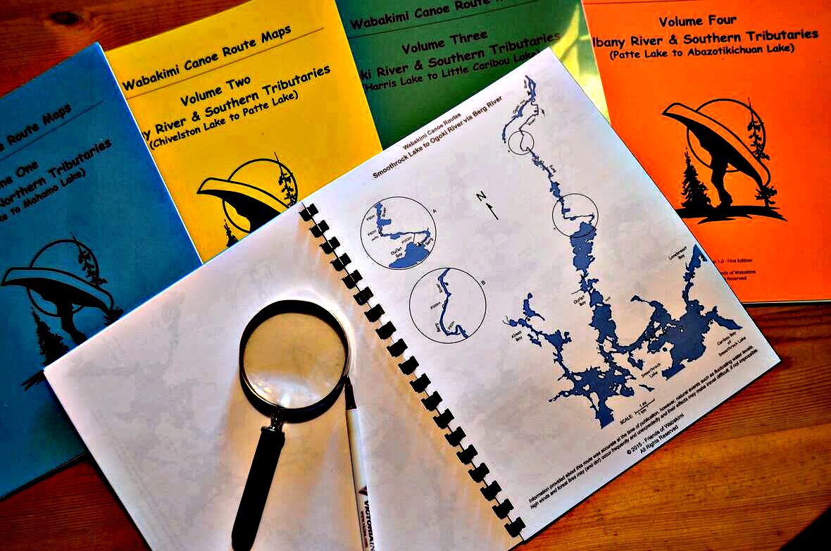
 Volume Five, Wabakimi Canoe Route Maps
$39.00$33.00 - Member price
Volume Five, Wabakimi Canoe Route Maps
$39.00$33.00 - Member price -
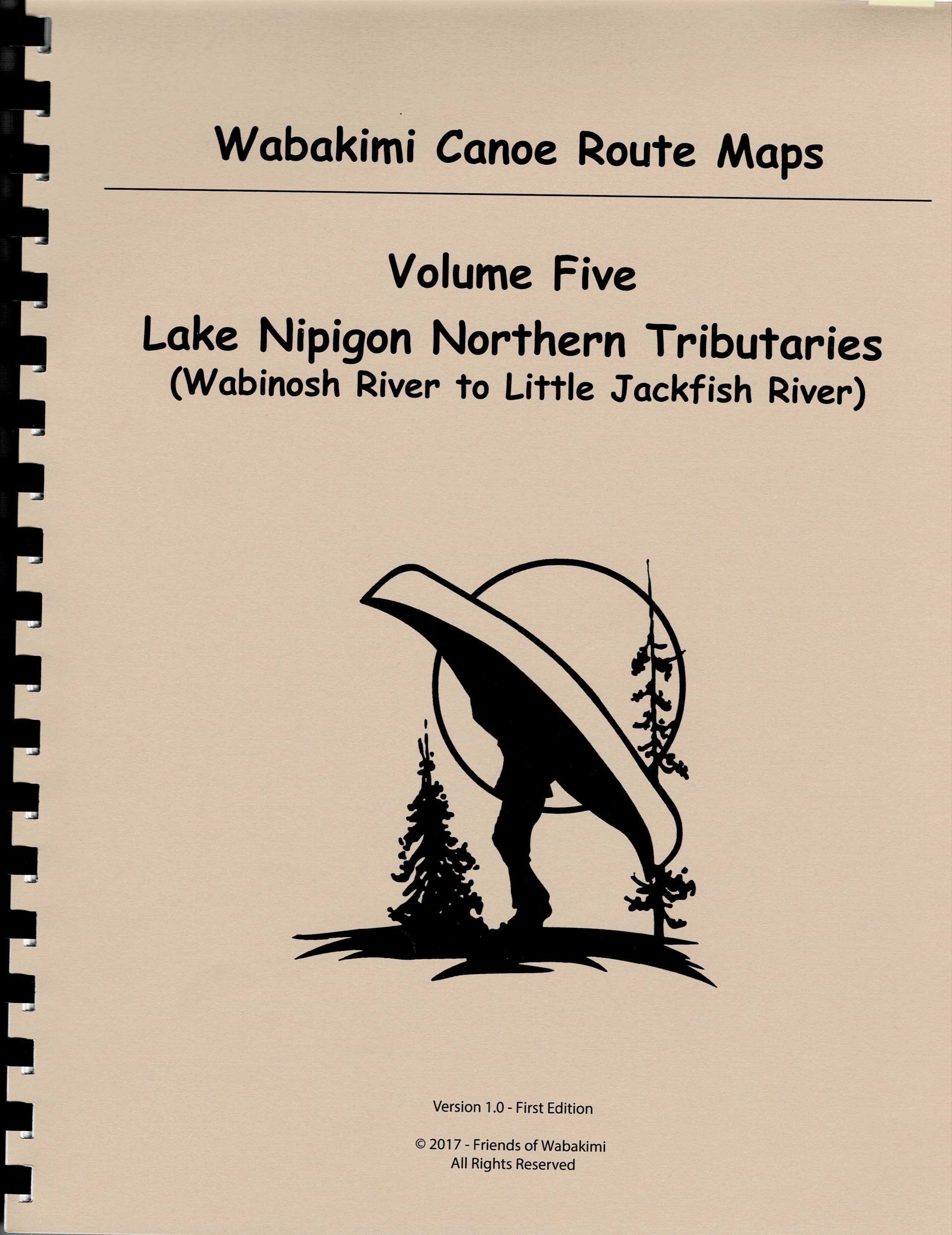 Volume Five, Wabakimi Canoe Route Maps (PDF DOWNLOAD)
$25.00$18.75 - Member price
Volume Five, Wabakimi Canoe Route Maps (PDF DOWNLOAD)
$25.00$18.75 - Member price -
 Volume Four, Wabakimi Canoe Route Maps
$39.00$33.00 - Member price
Volume Four, Wabakimi Canoe Route Maps
$39.00$33.00 - Member price -
 Volume Four, Wabakimi Canoe Route Maps (PDF DOWNLOAD)
$25.00$18.75 - Member price
Volume Four, Wabakimi Canoe Route Maps (PDF DOWNLOAD)
$25.00$18.75 - Member price -
 Volume One, Wabakimi Canoe Route Maps - PDF DOWNLOAD
$25.00$18.75 - Member price
Volume One, Wabakimi Canoe Route Maps - PDF DOWNLOAD
$25.00$18.75 - Member price -
 Volume Three, Wabakimi Canoe Route Maps (PDF DOWNLOAD)
$25.00$18.75 - Member price
Volume Three, Wabakimi Canoe Route Maps (PDF DOWNLOAD)
$25.00$18.75 - Member price -
 Volume Two, Wabakimi Canoe Route Maps (Caribou Forest and Albany River P.P.)
$39.00$33.00 - Member price
Volume Two, Wabakimi Canoe Route Maps (Caribou Forest and Albany River P.P.)
$39.00$33.00 - Member price -
 Volume Two, Wabakimi Canoe Route Maps (PDF DOWNLOAD)
$25.00$18.75 - Member price
Volume Two, Wabakimi Canoe Route Maps (PDF DOWNLOAD)
$25.00$18.75 - Member price -
 Wabakimi Canoe Routes GUIDEBOOK (The first for Wabakimi!) Price is CAD.
$50.00$40.00 - Member price
Wabakimi Canoe Routes GUIDEBOOK (The first for Wabakimi!) Price is CAD.
$50.00$40.00 - Member price -
 Wabakimi Canoe Routes PLANNING MAP - 35" by 41.5" (Price in CND)
$35.00$27.00 - Member price
Wabakimi Canoe Routes PLANNING MAP - 35" by 41.5" (Price in CND)
$35.00$27.00 - Member price -
 'Wabakimi' Print (8x10) by Kevin Belmore
$30.00$23.00 - Member price
'Wabakimi' Print (8x10) by Kevin Belmore
$30.00$23.00 - Member price